MacDonald Pass
ONCE
A FRONTIER TOLL ROAD
|
Ten Mile Creek
RISES
IN THE ROCKIES |
Williams Street Bridge
VICTORIAN ROMANCE |
State Nursery & Seed Co.
1888-2001
|

Kessler Brewery
NICKOLAS
KESSLER WAS BELOVED
|
Central Park
NOW
GREEN MEADOW
COUNTRY CLUB
|
 Mount
Helena
Mount
Helena
NOW A CITY PARK |
Fort
Wm. Henry Harrison
SINCE
1894
|
Helena
Sand & Gravel
NOW SPRING MEADOW LAKE
|
 Seymer
Park Neighborhood
Seymer
Park Neighborhood
JULY
28 1965 |

Broadwater
Skating Rink
CONSTRUCTED
BY STREETCAR CO.
|
 Pine
Hills Golf Course
Pine
Hills Golf Course
AND
OTHER EARLY COURSES |
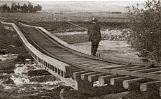 Streetcar
Bridge Washout
Streetcar
Bridge Washout
1908
FLOOD AT BROADWATER |
|
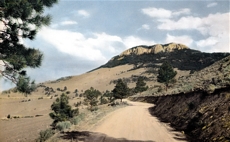 LeGrande
Cannon Blvd.
LeGrande
Cannon Blvd.
SCENIC
ROAD BUILT 1907-08 |